Topographic Map Project
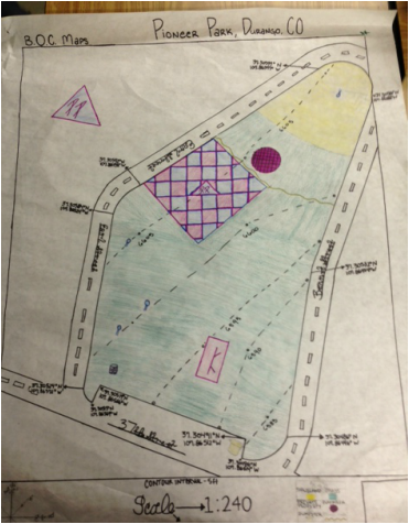
To make our map, we first walked the perimeter of Pioneer Park and recorded the number of paces each segment was. Then, we walked in straight lines (perpendicular to the curb) to any major trees or landmarks, such as the pavilion. In the case of the pavilion, we actually had to walk the width and length of it to find its exact size. To find the proper size and location of the private property inside the park, we also walked around its perimeter. Getting the curves of the park was a bit trickier-- one group member had to hold an end of a rope and stand on what was deemed the center of the circle the arc belonged to. The other group member would hold the other end of the rope and walk along the curb. Next, to get the latitudes and longitudes, we used a GPS to pinpoint the ends of the park's perimeter segments. The contour lines, showing a five foot change in elevation per interval, were found by Mr. Heerschap, who used a laser to figure the exact numbers.
